|
|
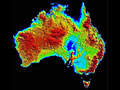
Welcome to the Australian Soil Resource Information System
ASRIS provides online access to the best publicly available information
on soil and land resources in a consistent format across Australia. It
provides information at seven different scales (view animation).
- The upper-three scales provide general descriptions of soil types,
landforms and regolith across the continent.
- The lower scales provide more detailed information in regions where
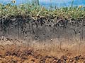
mapping is complete. Information relates to soil depth, water storage,
permeability, fertility, carbon and erodibility. Most soil information
is recorded at five depths.
- The lowest scale consists of a soil profile database with fully characterised
sites that are known to be representative of significant areas and environments.
|
 |